Universal Traveler

Just a dude with a backpack, a plane ticket, and a nasty case of intercontinental wanderlust.

Name:
Location: Minnesota, United States

Sunday, February 27, 2005

Aspiring to Greatness

After lazing around Wanaka for a while, I was eager to head back into the wilderness and get my tramp on. So, I decided to make a brief (2-3 day) trip into Mt. Aspiring National Park. It's one of the best places in NZ to experience the alpine beauty of the Southern Alps, and Wanaka has convenient access to the park's Matukituki Valley region, so it all came together pretty well.

I was all geared up and ready to go on Saturday morning when I jumped in Blue Steel and...she wouldn't start! Not only would she not start, but the engine wouldn't even turn over. Each turn of the key yielded no response.

SHIT!!!

After an unsuccessful jump start attempt, I walked over to the local service station to ask for advice. The mechanic guessed that something might be wrong with the starter motor, but said that their only "sparky" (electrical expert) was off duty that day and wouldn't be back in until Monday. But he suggested that I pop the hood and give the starter motor a few good taps with a wrench, just to see if that helped.

Well, it sounded like lame advice, and I was trying to get comfortable with the idea of being stranded a few more days in Wanaka, but I figured I should give it a try anyways. After tapping the hell out of the starter motor, I unenthusiastically got back in the driver's seat and gave it a try. And it worked! I was amazed. I never got the name of that Wanaka mechanic, but whoever you are, you are a prince among men.

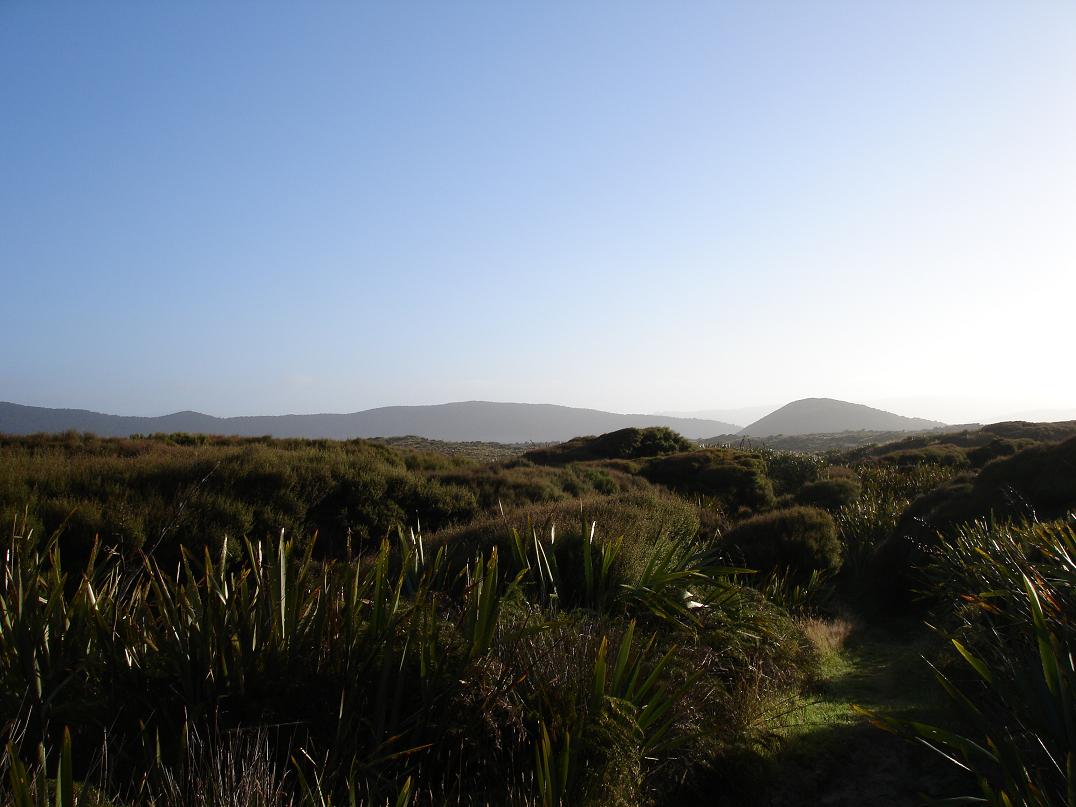
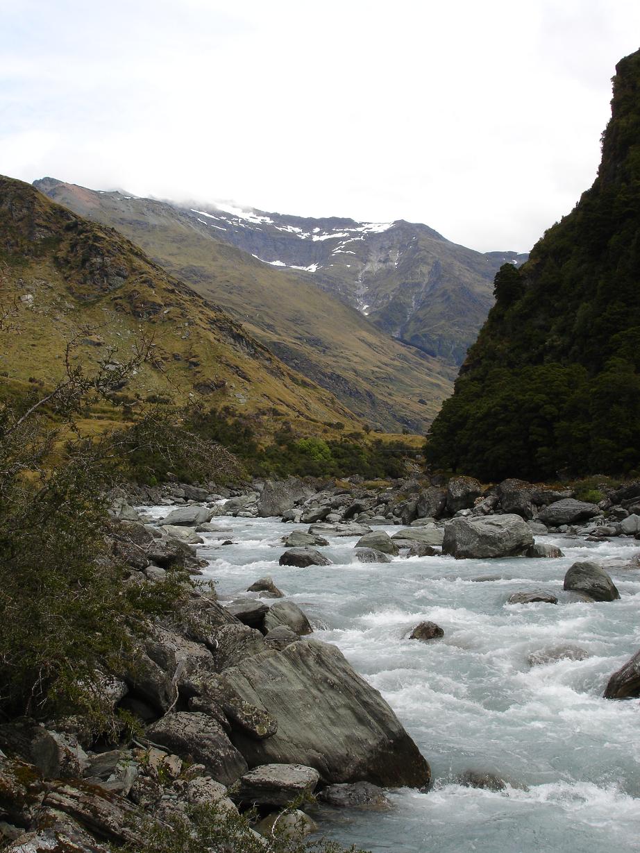
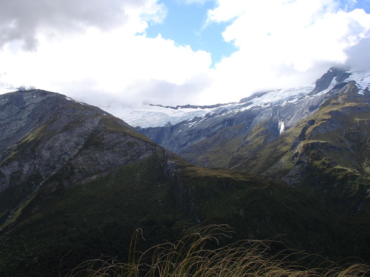
Anyways, after that ordeal I drove to the Raspberry Creek carpark in Mt. Aspiring National Park and started my hike. It began with a 4-hour tramp through the Shovel and Pearl Flats in the Matukituki Valley, with the peaks of the Southern Alps surrounding me on both sides. I could see glaciers and snow fields at high altitudes, and each of these spawned spectacular glacial waterfalls that cascaded all the way down into the valley.

Here is a shot of the Matukituki Valley as I was crossing the flats:

After passing the flats, I began the gruelling, 1200-meter ascent up the side of Mt. Barff to the Liverpool Hut. (Yes, I did chuckle a bit at the fact that I was climbing Mt. Barff, although I was slightly disappointed that there was no Mt. Poopp or Mt. Snott nearby). It was a real knee-bender of a climb...far more difficult than anything I had done previously. And it only got harder when it started drizzling at around 500 meters. Yowza. Anyways, you can imagine that I was relieved to finally reach the tiny, 6-bunk Liverpool Hut, shown in this photo:

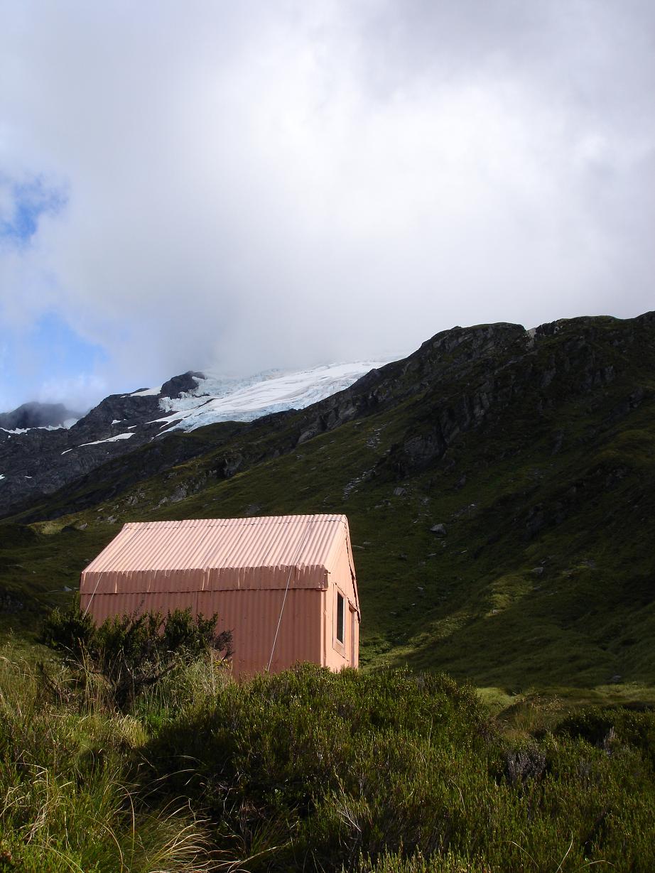
I had to wonder if the location of the hut was the result of a dare or something, because it was basically perched on a ridge above the treeline in the middle of nowhere. But the surroundings lent a truly rugged and remote air to the place, and it was a great place to spot to spend the night.

While in the hut, I occupied myself by compiling a short list of humorous log book comments. See, each DOC hut has a log book that is filled out by anyone who visits the hut, and each line includes a "comments" field where trampers write, well, whatever they feel like. It's often quite entertaining to read these entries:

  • "Kiwis are the closest God ever came to creating a Pokemon."
  • "We are under attack! They came in the night and started banging on the door and window. Big keas (irritating alpine parrots) with madness in their eyes!"
  • "Hope the giant rat doesn't come and the men don't snore."
  • "Came in search of alpine whores but didn't find any. Saw a kea but couldn't root it."
  • "Resident mouse can kiss my ass."
  • "It's like snefling with puf the rop." (Note: I think psychotropic drugs may have been involved with this comment).

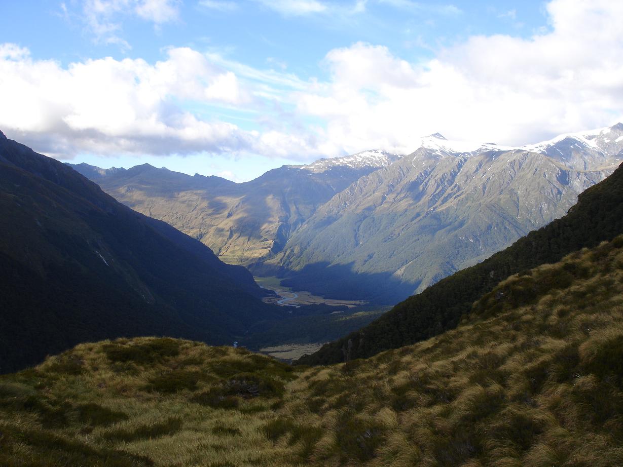
The views from the hut were also quite good, although high cloud prevented me from getting a clear glimpse of Mt. Aspiring:

Anyways, it rained like a mofo all night and it was quite cold in the morning, so I was getting a little nervous about the weather. I wasn't cool with the idea of being stuck in the hut, so I decided to descend Mt. Barff on Sunday. This turned out to be an excellent idea, because when I met another group of hikers on the way down and asked if they knew the forecast, they said "snow and hail." Wow, glad I didn't stick around for that. Even though there was no solid precipitation, it still rained all the way down, which made the descent awfully perilous, probably the most dangerous stunt I have yet attempted in NZ.

An unfortunate side effect of the tramp was that my boots got kinda shredded on the way up...they both have holes now! So I'm thinking I might give tramping a break for a while, unless I'm sure the weather is going to be good. I feel like I'm sort of drifting at the moment, which isn't necessarily a bad thing. Updates to follow, of course.

Friday, February 25, 2005

Come to Wanaka...to celebrate Hanukkah!

Sort of a nonsensical post title, but if you have ever heard "The Hanukkah Song" by Adam Sandler, you will understand why the Wanaka-ized version has been in my head EVER SINCE I ARRIVED HERE.

After I left Stewart Island, I was looking for a good place to chill out and re-socialize for a bit, and Wanaka has been fitting the bill quite nicely. It has a very laid-back attitude, and the surrounding lake and mountain scenery is beautiful. Yesterday I met an English woman named Annie, and we decided to hang out and spend the day together. We started out at the Stuart Landsborough Puzzling World, which is home to oodles of optical illusions, holograms, brain-teasers, and a famous, gigantic outdoor maze. The maze has four colored towers in each corner, and, ideally, you make your way through the maze and hit each tower in sequence. After breezing through the red, blue, and yellow towers, we suddenly found ourselves going in circles trying to find the green tower. (And yes, Stu, at several points I thought to myself, "you have now found yourself...trapped in the incomprehensible maze"). I am sorry to say that since it was very hot out (and we were giant wusses), we decided to abandon the maze without ever reaching the green tower. Damn you, green tower...damn you to HELL!!!

Being thoroughly parched from our a-maze-ing (HA!) experience, we decided to stop by Slainte, a local Irish pub for a beer. Well, somehow this turned into a drinking spree that would last well into the evening. We sat out on the patio, sipping Speights and Guinness, just relaxing and enjoying the weather and the conversation. Later that night we went to a seafood restaurant for dinner...it was so nice to have a quality meal after so many days trapped in freeze-dried purgatory. Afterwards we went back to Slainte to keep our drinking momentum going, and were just in time to enjoy a nice little Irish folk band that was playing.

Today Annie and I met a German girl named Rena, and we were all planning on buying tickets to a Black Seeds (a NZ reggae band) show tonight, but they were sold out! Maybe we will hit the posh Cinema Paradiso for a movie instead. I am pretty sure that this will be my last night in Wanaka for the moment, and that I will probably start a new walk sometime tomorrow, although I really have no idea where I feel like hiking. I suppose I will sort it out eventually.

To conclude this post, I figured it would only be fitting to offer the last verse of The Hanukkah Song (Wanaka-ized, of course):

"So drink your gin and tonica, smoke your marijuanika, and if you really really wannaka, have a happy happy happy time in Wanaka!"

How I learned to stop worrying and love the bush

Since some of you have been asking about the logistics of my Stewart Island/NW Circuit walkabout, I figured I would do a quick post to explain how I pulled it all together.

FOOD: I packed about 10 days worth of food, and I ate the same thing every day. 2 packets of instant oatmeal in the morning, cheese and crackers for lunch, trail mix for a snack, and a freeze-dried instant meal for dinner. Multiply that list by 10 and you have a pretty good idea of how much food I was carrying. It was a lot of weight at first, but my pack got lighter with each passing day.

CLOTHING: 3 t-shirts, 2 pairs of shorts, 1 pair of pants, 3 pairs of underwear, 3 pairs of wool socks, rain coat, and a fleece hat. As you can probably imagine, my clothes were unbelievably nasty by the 9th day. I coined a term for the condition they had attained: "terminal stankocity."

SHELTER: The nice thing about hiking in New Zealand is that the Department of Conservation maintains hundreds of backcountry huts along the tracks. Every night I stayed in one of these huts. They typically provide bunks with sleeping pads, a table with benches, a wood stove, and a sink with a rainwater faucet (which means that I never had to worry about purifying water). A sleeping bag is really all you need to stay in one of these huts.

OTHER GEAR: I did all my cooking with an MSR Pocket Rocket stove attached to an MSR IsoPro isobutane cannister. This setup worked great because all I ever had to do was boil water, which it did very quickly and with a minimum of weight and bulk. Probably my favorite bit of non-essential gear were the gaiters I purchased before the hike. They are basically just nylon pant legs that attach to the bottoms of your boots and extend up just below the knee, with the purpose of keeping mud, rocks, and other junk out of your boots. I was amazed at what a great job my gaiters did. My shoes always got plenty wet, but no mud ever made it inside. Possibly the best 40 NZ dollars I have spent yet.

So there you have it...thats how I survived 9 days in the Stewart Island wilderness. I you have any more specific questions, feel free to post another comment!

Tuesday, February 22, 2005

HE LIVES!

Well, after a long hiatus from the civilized world, it sure feels good to be back in a city, even if that city happens to be sleepy Invervegas. You've probably lost count by now, but I spent a grand total of 9 consecutive days hiking in the backwoods and beaches of Stewart Island. It was by far the longest backpacking trip I've ever been on, and it was an incredible experience. I won't bore you all with the day-by-day details, but hopefully I can distill the tramp down to the highlights:

The MUD: Maybe this doesn't deserve to be a "highlight" per se, but hey, mud is undeniably part of the character of the Northwest Circuit and of Stewart Island in general, so there it is. I'd say that, out of all the hiking I did, I probably spent at least 60% of it in the mud. Some of it was fairly dry and shallow, some of it was ridiculously sloppy and up to my knees. But it's not as bad as it sounds. In fact, I found that the Stewart Island mud bogs can be real character builders. After a serious bog or two, you realize that you can't simply skirt around the edges or find an alternate route. You just have to slog straight through...dry boots be damned. This straightforward mentality actually requires far less time and effort. Maybe this is a metaphor for life in general: when life deals you a mud bog, just bite the bullet and bash on through it. You may get a little (ok, a lot) dirty in the process, but you emerge a little bit stronger (and hardier) on the other side.

Here are some mudographic photos to satisfy your curiosity:

A typical Stewart Island mud bog. Actually, this one is pretty small. The longest one I came across was roughly 1 km long and featured knee-high mud (I am not joking). I was in too much of a hurry to GET OUT of that one to take a picture:

This is how my boots looked after a typical mud bog trounce:

The BEACHES: For me, Stewart Island's beaches made all the steep climbs, precarious descents, and never-ending mud bogs worth it. It is hard to convey just how rugged and remote they are. The best part is that pretty much whenever I came across a beach (which was just about daily), I had the entire place to myself. Having access to a beautiful beach is one thing, but being able to experience it in solitude really adds a new dimension.

Here are several random pics of the beaches I visited:

The DUNES: Stewart Island is somewhat unique in that it is home to a suprisingly large collection of sand dunes. My favorite beach, Smoky Beach, gets its name from the smoky appearance of the wind blowing sand over the dunes. One of the dunes is so extensive that it reaches up from the beach up to the top of a mountain pass, attaining an alititude of roughly 300 meters above sea level. In fact, when I first came across this dune, I had just been slogging through the aforementioned 1 km mud bog from hell. Just when I was thinking that the sloshing would never end and that I might soon find myself neck deep in mud, I stepped through a gap in the trees and found myself, inexplicably, surrounded by sand. It was one of the most bizarre changes of scenery I have ever experienced.

The BUSH: Since it is so remote, much of Stewart Island's forested land remains the same as it has been for hundreds, if not thousands, of years. Rimu, rata, and beech trees provide the canopy, while a lush collection of ferns and mosses coat the ground. Stewart Island's flora is a beauty to behold.

The SOLITUDE: According to DOC, fewer than 1000 people hike the Northwest Circuit each year, which means that you'll have plenty of time to yourself to muse, meditate, or, well, do whatever you want. For me, the most peaceful time of the tramp was when I hiked across Freshwater Flat from Mason's Bay to Freshwater Landing. I left early in the morning, and it was so amazingly quiet that if I stopped and stood perfectly still, all I could hear were the distant sounds of the ocean and my own breath. Ocean breathing, me breathing, and nothing else. Beautiful.

Well, this is turning out to be one hell of a post, and I am racking up one hell of an internet charge, so I should probably let things go here. I'm actually not sure where I'll go next...probably Queenstown or back to Dunedin since, after 9 days in the bush, I feel like I need to be re-socialized for a bit. I'll keep you posted.

Sunday, February 13, 2005

Journey to The End of The Earth

I decided long ago that I was going to make a trip to Stewart Island, the third island of NZ, just across the Fouveax Strait from Invercargill. It is unquestionably one of the more remote spots in NZ, and it features some of the most diverse and unspoiled plant and animal life in the country. The only question I had: which track to hike?
There are two main tracks on the island, and they couldn't be more different in character. Most people hike the 3-day Rakiura Track, which is serviced by relatively modern Great Walk huts and is lined with boardwalks to avoid most of the mud for which Stewart Island is famous. On the other hand, there is the 8-to-10-day Northwest Circuit Track, which covers a good chunk of the island's coast and is known as the muddiest track in New Zealand. It also reportedly has some of the best scenery.
Here's a basic map of Stewart Island. The Northwest Circuit follows the coast from Oban North to Mt. Anglem, then West towards the Rugged Islands, then South to the end of Mason bay, and finally cuts across the mainland back to Oban:

Well, yesterday, after an inspiring discussion with a Stewart Island tramper from Ohio, I made the decision to hike the Northwest Circuit. Am I crazy to do this? Maybe. Will I get my ass kicked by the mud and the muck? Probably. Will I even be enjoying myself by the 8th day? Well, I hope so. At the very least, will I feel a sense of accomplishment after completing the track? Definitely.
Anyways, odds are that I won't have internet access until I get back to Invercargill, so the blog will probably be silent for at least 10 days. In the meantime, send me some good vibes all the way accross the Pacific to Stewart Island! God knows I'll need them.

Beervercargill

As I mentioned in a previous post, I randomly bumped into Kate (Wash U '04) on the streets of Invercargill yesterday. I recognized her face instantly, but I couldn't remember how I knew her. Turns out that it was a pretty random connection: Kate lived on the same dorm floor as Laura, my ex-girlfriend, when I was a sophomore. I suppose it's amazing that we even recognized each other.

Anyways, Kate, her friend Maggie, and I went to a bar called "The Frog and Firkin" last night to celebrate our random encounter. We all made efforts to expand our repertoire of NZ beers: I had Export Gold for the first time, and they gave Lion Red a try. A good beer was had by all.

For some reason, the conversation eventually turned to scary stories. Kate told a brief but creepy story about a girl who hiked the Appalachian Trail and, as she was shuffling through the photos she had taken after the hike, she came accross 3 photos she didn't recognize. One of them was of her tent, the second one was also of her tent (but closer), and the third was of her sleeping in the tent. Yowza. I'm not sure if the story is actually true or not, but it's creepy nonetheless. If Stuart Lim is reading this post, he will be happy to learn that I told his famous (and true) "helloooooo" story. I think Kate and Maggie found it pretty scary. Later on, I was talking about my experiences camping alone in the Ozarks and in the Top Bus, and I tried to persuade them to give solo camping a try, but after all the scary stories we told, I don't expect them to follow through.

Saturday, February 12, 2005

One last Catlins post...

February 12, 2005

After I finished the Catlins Top Track, I hiked back to Papatowai and checked into the Hilltop Backpackers, which somehow managed to surpass The Falls as the best hostel I have patronized in New Zealand. It was quite a bit nicer than either of the apartments I lived in in KC, which I know doesn't say all that much. The fact that my bed cost me only $22 NZ is almost a crime. All I can say is that it really felt like a home.
I was lucky enough to be staying with a great group of guests that night. John and Jackie from England, Steve and Amanda from England, and Eileen from Ireland. We all had dinner together and talked late into the night. Steve and Amanda had recently gone on a cross-country RV tour through the USA, so we had a great time sharing our impressions of America. It was really interesting to hear their take on my home country, especially the midwest. Most overseas travellers never stop in "fly-over land," but Steve and Amanda had gone straight through and said it made up the best part of their trip. They both had love affairs with Krispy Kreme and, strangely, Wal-Mart.
Here's a picture of the group. From the left: me, Jackie, Rodney (owner of the Hilltop), Steve and Amanda, John, and Eileen:


The next day I drove South along the Southern Scenic route to check out Curio Bay, where I was to spend the night. Along the way I saw the following sights:
The Cathedral Caves, a series of cavernous coastal caves eroded by the sea. They are only accessible for a period of two hours before and one hour after low tide. I ran into Steve and Amanda here, so they took the picture of me at the mouth of the cave:


McLean Falls, which I think are the most impressive falls I have seen yet:


Unfortunately, once I got to Curio Bay I found out that the hostel I was supposed to stay at had lost my booking. I know for a fact that I had made the reservation on Monday, so I can only assume that signals got crossed somewhere along the way. It was no big deal, though. I just called the Hilltop back up and booked another luxurious night there.
There was a new group of people staying there and the atmosphere had totally changed. Everyone was more quiet in general, mainly because everyone spoke English as a second language. I did meet a pair of friendly Swedes who wrote a list of cool things to see in Sweden, for when I travel there this summer. I also had an interesting conversation with a guy from "the Basque nation." I originally misheard this as "the best nation" and thought that he was simply proud of his country. When I realized that he had said "Basque" and not "best," I almost said, "oh, you mean Spain?" but caught myself. For those of you not in the know, the Basque region is the part of Spain near the border with France. For many years some of the residents of the region have been fighting for recognition as an independent state. Some have even resorted to terrorism, as evidenced by the acts of ETA, the main Basque separatist movement. When the Madrid train bombings occurred last year, ETA was initially blamed. Anyways, I didn't know if this guy was really into separatist ideology, so I decided to play along and accept that he was indded a citizen of The Basque Nation.
Today I drove to Invercargill, known sarcastically by locals as "Invervegas." It's really not much more than a farming town. I'm only using it as a jumping-off point for Stewart Island, which I should be visiting on Monday. Interestingly enough, I just ran into someone I recognized from Wash U! We really weren't much more than acquaintances while we were actually in college, but we both recognized each other and decided to meet for beers later on tonight. It's a small world!
I'll try to post once more before I head off to Stewart Island. At that point, I would expect silence for at least a week. Don't give up on me, though...I'm sure I'll have lots of pictures and stories when I get back.

Pict-o-rama!

February 12, 2005

Alright, here's what you've all been waiting for. This should be a rough photographic summary of the things I've seen and done since I last posted photos. Enjoy!

Me and Hanne. I didn't realize that the picture was out of focus until I had already left Dunedin. But you get the idea:


Hanne took this picture of me with Lover's Leap in the background. You can just barely see it. I guess that my own majestic beauty was too much for Lover's Leap to handle, so it was forced to fade into the background. You can only fit so much beauty into a single photo:


Baldwin St. in Dunedin, the steepest street in the world:


The Nuggets, named, of course, after Nugget McSimpson:


Purakaunui Falls, after which The Falls Backpackers that I stayed at is named:


The view from The Falls Backpackers:


Me, Ian, Alan, and Debra, about to embark on our scenic tour of Ray and Debbie Francis' (the proprietors of The Falls) farm:


The Catlins Top Track

February 12, 2005

After leaving The Falls Backpackers in Owaka, I set of to Papatowai to start the Catlins Top Track. It is unique in that it is a privately owned and operated track that passes through private land, so it's a slightly different experience than a typical DOC (Department of Conservation) track through a national park. It is described as the longest and most varied track in the Catlins, so I figured it would be a good way to get a feel for the natural beauty of the area.
The track started along a 3 km beach, which was incredibly peaceful. Actually, for the entire first day of the track (it's 2 days long) I didn't see another person anywhere. Here's a pic showing the beach and the rocky outcroppings I traversed later:

On the other side of the cliffs shown above, I came across another beach with an ocean-worn rock formation that jutted out into the ocean. This is where I had lunch for the day:

After lunch, I continued through sections of farmland, regenerating bush, and rolling hills. Eventually reached the place where I would be spending the night: the "Top Bus." The Top Bus is actually a 1960s-era Dunedin city trolley that the operators of the CTT hauled up on one of the cliffs and converted into a cabin, complete with bunks, cooking facilities, a writing desk with a small library, and even a primitive shower:

At night, all I could hear was the sound of the wind (which was howling). I took in the sunset (which was marred somewhat by clouds) and wrote in my journal for the rest of the night:


The second day, unfortunately, was shorter and not as memorable as the first, but I had a great time nonetheless!

Thursday, February 10, 2005

The Catlins

Since Tuesday I have been slowly taking in the sights, sounds, and smells of the Catlins, the coastal region between Dunedin and Invercargill. It's a very beautiful and interesting place. In the 1960s much of the forests covering the hills were logged and burned to create farmland and pastures for sheep, so the landscape is a mix of rolling pastures and dense bush. I have come to appreciate both forms.

On Tuesday I visited mostly beaches and coastal cliffs. The most notable stop was Nugget Point which features a short walk to a still-operational lighthouse from the 1870s and views of a geological oddity called (what else) the Nuggets. The Nuggets are basically a group of rock formations jutting out of the sea just off the coast. Of course, Nugget Point gets its name from the Nuggets which, indeed, look kinda like nuggets of some sort, but I decided that I would dedicate the area to Nugget McSimpson, the alter-ego of my Wash U comrade TJ Peterson.

Tuesday night I stayed at my favorite hostel yet, The Falls just Southwest of Owaka. It's a really tiny place on a sheep farm owned by caretakers Debbie and Ray, and it actually felt like a house/home instead of a hostel. Debbie actually took the time to make sure that all the guests were introduced to each other, so I met Graeme and Adrian from Christchurch, Ian and Jayne from the UK, Alan from Copenhagen, and Debra from Seattle. It was a very friendly atmosphere and we spent all our time together chatting.

The best part came later that night. Ray asked us if we wanted to see the farm, and Ian, Alan, Debra and I obliged. We climbed up into the back of his pickup truck and stood up, holding on to a frame in back of the cab. (Note: This, of course, would never fly in the USA due to legal liability. Another reason why NZ is a breath of fresh air.) We drove all over the farm as the sun was setting, observing the surrounding hills in the wonderful dusk light. Ray let his working dogs out, and they all ran alongside the truck, occasionally breaking off to tend to an errant sheep. He took us to the highest point on the farm, where we were treated to fantastic 360-degree views. It was dark by this time, and the night sky was gorgeous as well. Along the way, Ray would periodically stop to talk to us about the ins and outs of sheep farming, and I learned an awful lot about the life of a sheep farmer.

When we got back to the hostel, Ian, Jayne and I walked down to the Purakaunui falls to look at the glow worms. They were all over, forming little constellations of pale blue/green light on the slopes surrounding the falls. On the way back, Ian semi-successfully tried to scare the shit out of Jayne and I by making scary voices and noises.

Well, I have racked up a substantial internet fee here in Owaka (the only internet access anywhere near Papatowai), so I should sign off for now. Trust me, the pictures are coming. See you in Invercargill!

Lightning strikes thrice

February 10, 2005

I'm having a hell of a time trying to find a place in the Catlins that will let me upload my pictures, so that will probably have to wait a day or two when I get to Invercargill. When I get there I'll try to post a ton of photos to make up for their absence up to this point.
Anyways, let me go back to Thursday the 7th, if you will. I spent the day running errands (getting a haircut, buying hiking supplies) and visiting minor tourist sites. These included Baldwin St., which is certified by the Guinness Book of World Records as being the steepest street in the world! Of course, I had to walk to the top and back, and it was plenty of work.
My last errand was to make a run to The Warehouse (like Wal-Mart, only crappier, if that's possible) to buy some plastic storage bins to organize Blue Steel's jumbled trunk. While I was there, it suddenly started pouring outside...and I mean POURING. Apparently the sky dropped 37 mm in 1 hour, and half of that was in the first 15 minutes. It was Dunedin's worst flash flood in 5 years, and total damages were estimated to be in the millions. I wandered around the Warehouse and waited for the worst of the rain to pass, and when I finally emerged, there were rivers flowing in the streets. It was crazy.
I had a quick dinner back at the Elm Lodge, but I didn't feel like reading and no English-speakers were around to chat, so I decided to venture out for coffee. Well, about 10 minutes into the journey the rain picked up again, so I decided to turn around. I was rounding the corner to go back to the hostel, and guess who I saw? Yep, it was Hanne again. I was beginning to think that maybe the gods were trying to send me a message about this woman or something. In a display of Norwegian hardiness and stoicism, she was trudging back from the convenience store in full wool garb, so of course she was soaked, but it didn't seem to bother her. Since it was such a serendipitous meeting, we decided to turn around and go out for coffee together. We went to a cafe called The Percolator and discussed music, among other things. I displayed my knack for "Name That Tune" by recognizing all the songs that were playing within the first measure or two. Hanne tried in vain to think of a Norwegian band that I might have heard of before. A good time was had by all.
On Tuesday I continued South to the Catlins region. I think I'll write about it in a separate post.

Monday, February 07, 2005

I feel Dunedin...Dunedin for spedin.

That horrible pun only makes sense if you know how to pronounce the name of the city I've been staying in for the past several days: Dunedin (pronounced duh-NEE-din). I've been having a really great time here. The town has a palpable Scottish influence that you notice everywhere from the architecture (neo-Gothic, often inspired by the buildings of Edinburgh) to the local accents (a slight Scottish "burr"). The weather has been great except for today, which is okay since I was planning on running errands today anyways.

Things got off to a rocky start, though, both literally and figuratively! On Friday, I drove towards Dunedin from Oamaru, taking a brief stop along SH1 to see the Moeraki boulders (pictures to come). These are basically a group of giant stone spheres, some up to 2 meters in diameter, sitting on the beach. It looks like somebody must have carved them and dumped them into the surf, but they were actually naturally formed. I'm no geologist so I won't even try to fully explain how they were formed, but it had something to do with mineral deposits attracting various sediments (forming the spheres) and then the sea eroding the cliffs where they were buried, causing them to fall onto the beach. Anyways, once I got into Dunedin, I found out that the hostel I had booked (called Hogwartz, although there was nothing Harry Potter-ish about it) had bungled my reservation. So they sent me to another hostel up the street, the Elm Lodge, which turned out to be fine.

At the Elm Lodge, I met Hanne, a geology student from Norway who had come to Dunedin to pursue her master's at the University of Otago (NZ's largest university). She was staying at the Elm Lodge while she searched for a flat to rent in the area. We chatted for a few hours about various things...she was surprised to learn about Minnesota's ties to Norway and thought it was funny that we were so enthusiastic about lefse and, in some rare cases, Lutefisk (she was a fan of neither). We went out for dinner later that night where she had sushi for the first time. For some reason, I seem to have adopted the role of sushi ambassador as of late.

On Saturday I went back to Hogwartz and booked two nights there. I spent the day watching a concert featuring Tongan music in the Octagon (Dunedin's city center), visiting the Dunedin Art Gallery, and having lunch/reading/relaxing in the Dunedin Botanic Gardens. The art gallery had a special exhibition of roughly 50 photographs of 90's-era Tokyo youths dressed in garish, avant-garde, home-made clothes. The exhibition was called "Fruits," ostensibly because the style of dress was fresh and colorful, but I had other connotations in mind.

I woke up a little early on Sunday morning to have a relaxed breakfast and do some laundry. I was heading out the back door with all my dirty clothes when who should I run into but Hanne! Turns out that Hogwartz rented flats in the house and she had chosen one of them. She was trying to fill the tires of the bike that the Hogwartz staff had lent her, but it seemed that one of the valves was broken, preventing the tire from taking on air. She had been hoping to bike out to the Otago peninsula, and since I didn't have any plans for the day, we decided to drive out there together.

We visited a smaller garden, which was sort of a waste of time as it was nowhere as good as the Dunedin Botanic Gardens. Then we went to explore Larnach Castle, and ostentatious castle/chalet (NZ's only) built by Dunedin enterpreneur/politician William Larnach in the mid-late 1800's. The place had some cool history, and it was interesting to see how Otago's high society lived 150 years ago. Finally, we went to hike some short tracks on the peninsula. A short loop track brought us (via sheep-shit-covered trails) to geological points of interest with dramatic names such as "Lover's Leap" and "The Chasm" (again, photos forthcoming). Although it was cloudy, the views from the lookout points were beautiful. Our last track was little more than a sandy path out to Allen's Beach, but the beach itself was gorgeous. White sand, clear water, and big waves. Somehow Hanne convinced me to go swimming with her in the surf which was, as they say, "cold as." Once we had our fill of the chilly water (didn't take long), we went back to the beach and basked on a volcanic boulder to dry off.

When we got back to Hogwartz, we treated ourselves to a spaghetti feast which, to our delight, only cost us $6 NZ apiece. I spent the rest of the night reading and relaxing in the hostel. I figured that my grandma (on my mom's side) would be pleased as punch to learn that I had spent the day hanging out with a Norwegian, so Grandma, if you're reading this, this post's for you.

Which brings me to today. Since I am apparently not very good at booking hostel rooms far enough in advance, I had to move back to the Elm Lodge this morning, which is alright by me. It's kind of drizzly outside, which makes it a good day for doing errands and getting other necessary business out of the way. Tomorrow I am venturing into the Catlins coast region, which is the stretch of coast between Dunedin and Invercargill on the South Island. Supposedly there is some beautiful scenery to be taken in around there. I will probably spend a few days in the Catlins before I head into Invercargill, and then (hopefully) on to Stewart Island. I'll post pictures of my Dunedin exploits as soon as I get a chance.

Friday, February 04, 2005

Oamaru: A Photo Essay

Ok, so maybe this doesn't qualify as a bona fide photo essay, but here are some pictures I took around the quiet city of Oamaru:

The spire of St. Luke's Anglican Church:

The next three shots are of the Oamaru Public Gardens. The gardens are surprisingly elaborate and beautiful. You wouldn't expect to find them in a small town like Oamaru. They are a symbol of the bygone days when Oamaru was a thriving seaport and a major exporter of wool, lamb meat, and the Oamaru whitestone for which it is famous (at least in NZ):

Thursday, February 03, 2005

Of Penguins and People

Yesterday I drove into Oamaru, which is billed as "The Penguin Capital of New Zealand," due to it's location near blue-eyed and yellow-eyed penguin colonies. I figured that since I had decided to stay in town for a while, I might as well make an effort to see the (blue-eyed) penguins. It's not as easy as you might think, though. First of all, they are only 10" tall (the smallest penguins in the world) which makes them pretty difficult to spot. Second, the majority only swim ashore at a particular time and location each night. So the resourceful Oamaru townsfolk have set up a special blue-eyed penguin viewing area, with bleacher-style seating and narration by a marine biologist.

So, as the sun was setting yesterday evening, I walked from the campground where I was staying down to the viewing area. This turned out to be somewhat of a mistake, since what appeared on the map to be a 15-minute walk turned into a 35-minute trek. Anyways, I got settled in on the bleachers and stared out to sea as the sun disappeared and the coast was enshrouded in fog and mist. Sure enough, at about 9:30 PM, a few tiny blue dots appeared along the shore. The penguins would swim ashore, often flung to and fro by the surf, and hop/waddle onto the rocks. Then they'd stop and congregate for a while, preening and smoothing their feathery coats to make sure they'd be waterproof when they next went out to sea. Finally, they would scale the rocky slope up to a dirt road, crawl through a wire fence designed to keep out terrestrial predators (mainly dogs, cats, and possums), and disappear into the brush.

I watched this spectacle unfold for a while and then, satisfied that I had had an appropriate penguin experience, decided to leave. By this time it was totally dark outside, and the fog and mist, combined with the relative silence (apart from the normal sea sounds), created an eerie scene. As I walked along a coastal road, past the docks, I was occasionally passed by cars carrying other exiting penguin-watchers, mostly tourists from Germany, the Netherlands, and Japan. I was approaching a seaside warehouse when I saw two bright flashes of light illuminate the street. I continued walking, not sure of the source of the flashes, since it was obscured by the building. As I got closer, I saw a man come around the corner of the building, and there was one more flash before he got in a car and drove off.

The scene struck me as sort of weird, so I was cautious as I approached the warehouse. Once I got close, I realized what all the flashes were about: standing stock still, not 10 feet away from me, was a tiny blue penguin, huddled next to a scraggly bush beside the warehouse. I stopped in my tracks and stared at him. And he stared back at me. Neither of us moved. We watched each other in silence for a few seconds, and then I continued my walk back to the campsite.

It's incidents like these that make me upset about the attitude of some tourists. We were all specifically told not to use flash photography (it scares the penguins), but this guy felt the need to chase this little penguin around, flashing happily away, so he could have something for his scrapbook. Does he care that he probably scared that penguin shitless? Does he care that if enough tourists like him did the same thing, they could potentially alter the nesting behavior of those penguins forever? I don't know. But I hope that as I continue my travels, I will never fall victim to the same sense of entitlement.

Tuesday, February 01, 2005

Let's get peninsular!

Today, eager to escape the hustle and bustle of Christchurch, Hopie and I set off on a day trip to Akaroa, a French colonial town on the Banks Peninsula. We decide to take the scenic route recommended by my guidebook, which was somewhat treacherous. We drove on narrow, winding, variable-quality roads along the northern coast of the peninsula, hoping to catch some views of the countryside. Unfortunately, we missed a lot of them because we were socked in with fog and clouds, but when the air cleared the scenery was absolutely stunning. Although at one point (when we were driving along a rough, one-lane gravel road) I almost thought Blue Steel would expire from all the abuse, we eventually made it into Akaroa.

Map showing Christchurch, Banks Peninsula, and Akaroa:

The town itself was really nice...a great place to spend an afternoon. We had lunch at a tiny seaside restaurant with great views of the harbor. The place was little more than a kitchen room with a small bar at one end and a small group of tables and chairs, but the food was great, and it was nice just to tone things down for a while. Afterwards we browsed through the town and had drinks at a local cafe.

I didn't take this picture, but it's a pretty good shot of the town of Akaroa:

By today, we both realized that we were ready to part ways. Not that we didn't enjoy each other's company, but I think we are both on independence kicks at the moment and eager to strike off on our own. I'm excited to explore the South part of the South Island, especially Stewart Island and Fiordlands. But I think I'll take my time getting there. Tomorrow I'll probably spend the night in Oamaru, and after that, who knows? I may not be able to post in a while, so don't be surprised if things are quiet for a bit.

Hope all the "folks back home" are doing well and not freezing their arses off!